Address
Access these items through using the address prefix. For example: address.latitude.
| name | type | description | example |
|---|---|---|---|
| address_id | string,null | Local unique identifier assigned to this address. | |
| address_line1 | string | Street address for the incident location. | 2600 BROOK RD |
| battalion | string,null | The battalion of the incident location. | 1 |
| building_number | string | The building number. | |
| city | string | The city associated with the incident location. | Richmond |
| common_place_name | string,null | A commonplace name for the incident location. | |
| cross_street1 | string | The name of the first incident cross street. | DUBOIS AVE |
| cross_street2 | string | The name of the second incident cross street. | EDGEHILL RD |
| distance_from_fire_department | number | The distance from the fire department to the emergency. | 2.1 |
| elevation | number | Height in feet above sea level. | |
| first_due | string | The apparatus station which is expected to be the first unit to arrive at the scene. | 14 |
| floor | string | The building floor number. | |
| geohash | string | ||
| latitude | number | The latitudinal coordinate of the location as decimal degrees in the WGS84 coordinate system. | 37.566419 |
| location | string | All location fields can be automatically calculated if not provided by source. | |
| longitude | number | The longitudinal coordinate of the location as decimal degrees in the WGS84 coordinate system. | -77.449261 |
| name | string | The street name of the incident location. | |
| number | string | The number portion only of the incident street address. | 2600 |
| population_density | string | Population per unit area definitions such Urban, Suburban, Rural and Wildland. | Urban |
| postal_code | string | The zip code associated with the incident address. | |
| prefix_direction | string,null | The prefix direction of the incident location. | |
| response_zone | string | The name of the geographical response area, also commonly referred to as box. | 907301 |
| state | string | The state associated with the incident location. | VA |
| suffix_direction | string,null | The suffix direction of the incident location. | |
| suite | string | The suite or apartment number. | |
| type | string | The street address type (ie ST, RD) | RD |
Address.location
Contains spatial data enrichments. Some of the fields provided by default are described here.
Census 2010 tract data
Often an optional parameter in fire incident reports, the ability to link fire data to census geographies provides access to a wealth of demographic and economic factors. Further technical documentation regarding the 2010 census data and corresponding geometries can be found in the Census 2010 TIGER/Line Shapefiles dataset.
| name | type | description | example |
|---|---|---|---|
| block | string | Block number from 2010 Census | 2034 |
| block_group | string | Block_group number from 2010 Census | 2 |
| census_id | string | GEOID of block from the 2010 Census | 390410122002034 |
| description | string | Human readable block name from 2010 Census | Block 2034 |
| population_density | string | Population density classification of block from 2010 Census | U |
| tract | string | Tract number from 2010 Census. | 012200 |
Social Vulnerability Index (SVI)
The Social vulnerability index is a collection of pre-processed variables from the American Community Survey (ACS) that are subsequently ranked by percentile either within states or nationally. The variables used have been selected based on apparent correlation in literature with the ability of a family to recover from a catastrophic event. For the summary metrics, the closer a value is to 1, the more vulnerable to catastrophe families in that area are based on the underlying ACS characteristics.
This index is maintained by the CDC and the SVI 2016 Documentation is publicly available.
SVI Themes
The Social Vulnerability Index is comprised of an overall vulnerability score calculated using four underlying "themes", which are themselves determined using logical groupings of ACS variables.
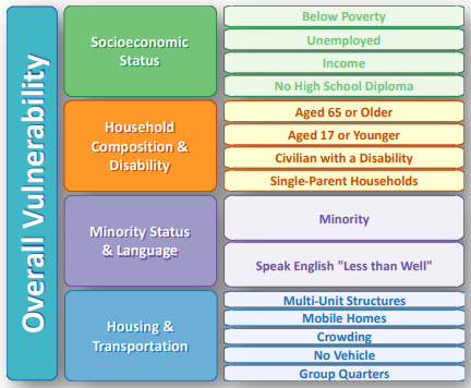
Note that “Minority” here is defined by the CDC’s processing of the ACS racial characteristics as “Any non-white race.”
SVI fields available in NFORS
The following table provides the mapping between native SVI fields and their corresponding name in NFORS.
| NFORS Field Name | SVI native field name (see SVI 2016 documentation) |
|---|---|
| summary.overall | RPL_THEMES |
| summary.household_composition | RPL_THEME2 |
| summary.housing_transport | RPL_THEME4 |
| summary.minority_status_language | RPL_THEME3 |
| summary.socioeconomic | RPL_THEME1 |
| household_composition.disabled | E_DISABL |
| household_composition.disabled_percentage | EP_DISABL |
| household_composition.over_age_65 | E_AGE65 |
| household_composition.over_age_65_percentage | EP_AGE65 |
| household_composition.single_parent | E_SNGPNT |
| household_composition.single_parent_percentage | EP_SNGPNT |
| household_composition.under_age_17 | E_AGE17 |
| household_composition.under_age_17_percentage | EP_AGE17 |
| housing_transportation.crowding | E_CROWD |
| housing_transportation.crowding_percentage | EP_CROWD |
| housing_transportation.group_quarters | E_GROUPQ |
| housing_transportation.group_quarters_percentage | EP_GROUPQ |
| housing_transportation.high_density_housing_units | E_MUNIT |
| housing_transportation.high_density_housing_units_percentage | EP_MUNIT |
| housing_transportation.mobile | E_MOBILE |
| housing_transportation.mobile_percentage | EP_MOBILE |
| housing_transportation.no_vehicle | E_NOVEH |
| housing_transportation.no_vehicle_percentage | EP_NOVEH |
| minority_status_language.limited_english | E_LIMENG |
| minority_status_language.limited_english_percentage | EP_LIMENG |
| minority_status_language.minority | E_MINRTY |
| minority_status_language.minority_percentage | EP_MINRTY |
| socioeconomic.no_highschool_diploma | E_NOHSDP |
| socioeconomic.no_highschool_diploma_percentage | EP_NOHSDP |
| socioeconomic.per_capita_income | E_PCI |
| socioeconomic.poverty | E_POV |
| socioeconomic.poverty_percentage | EP_POV |
| socioeconomic.unemployment | E_UNEMP |
| socioeconomic.unemployment_percentage | EP_UNEMP |
| general.area_sqmi | AREA_SQMI |
| general.daytime_population | E_DAYPOP |
| general.fips | FIPS |
| general.households | E_HH |
| general.housing_units | E_HU |
| general.total_population | E_TOTPOP |
| general.uninsured | E_UNINSUR |
| general.uninsured_percentage | EP_UNINSUR |